|
Click part of map or name of area for further details. |
 |
Slide Shows on Cathedral and Church Architecture - by Michael G Hardy
return to home page go to list of slide shows
|
A Tour of the Parish Churches of Buckinghamshire - in 4 parts |
|
Details of Slide Shows - by Michael G Hardy |
|
General Description of Slide Shows Four Slide Shows Map of County |
General Description of Slide Shows
These shows look at some of the parish churches within the historic boundaries of the county of Buckinghamshire. They are presented in the form of a tour, looking at churches in small local areas, generally in chronological order using the predominant period from which each church appears to date.
They are a personal selection (including about half of those in the county) of some parish churches showing and explaining some of the outstanding and the more unusual architectural features, monuments, church fittings and furnishings, stained glass, and historical connections that have survived in our churches.
Features can sometimes be found that date back to before the Norman Conquest, but these shows look at work from all centuries. These slide shows aim to demonstrate the amazing diversity of craftsmanship from all periods that has built up over the last 1000 years that has given us the precious heritage of our English Parish Churches.
There is no attempt made in these shows to compare the churches, or show how they developed across Buckinghamshire over the centuries. This is notoriously difficult to do as they were prone to influences from all directions. It is however hoped that the often unique character of churches in specific areas will be very apparent, usually dictated by materials and finance available.
Please note that two important areas are within the historic county of Buckinghamshire, and thus included in this series of shows. Firstly the administration of Slough and the area around it was transferred to Berkshire in 1974. This lasted less than 25 years until the administration of Berkshire was carved into 6 Unitary Authority areas, Slough being one of them. The second area which has been lost to the administrative county of Buckinghamshire now falls under the Unitary Authority of Milton Keynes. This area not only includes the area of the City of Milton Keynes, designated as such in the 1960s, but also some land to the east of it, and the large area to the North of the city itself, reaching up to Olney and beyond.
|
There are 4 different shows, covering the following areas, all within the historic boundary of Buckinghamshire:
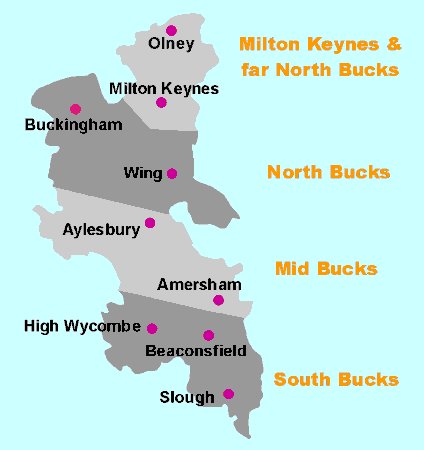
Milton Keynes and the far North of Bucks From the border with Northamptonshire down to the Southern edge of Milton Keynes. North Bucks From the Southern edge of Milton Keynes down to Grendon Underwood, Whitchurch and Pitstone. Mid Bucks From Ludgershall, Waddesdon, Bierton and Aylesbury down to Bledlow, the Missendens and Amersham. South Bucks From Radnage, Penn Street, and Chalfont St Giles down to the River Thames and the border with Berkshire.
For further details of each area, click here, or on map below: Milton Keynes & far North Bucks North Bucks Mid Bucks South Bucks |
|
Click part of map or name of area for further details. |
|
|
Slide Shows on "Parish Churches of Buckinghamshire" |
|
return to general description return to 4 slide shows return to map of county |
This page last modified on 15th December 2005